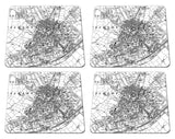
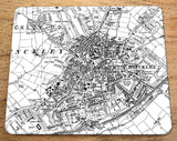
19th Century Ordnance Survey Map Postcode Centered Placemat - Set of four
19th century Ordnance Survey maps professionally printed onto placemats. An ideal and unusual gift!
Find out what your area was like in the past. The map covers an area of 2km x 2.4km and is highly detailed. Perfect for using as tableware and a great talking point.
The OS map can be centered on a postcode or area of your choice. You might personalise it by choosing a location of a birthplace, marriage venue or current home to make a thoughtful and historically interesting present.
To order, please add the item to your cart and add a note to the special instructions field to let us know your choice of postcode or area (and which item to apply it to if you have multiple purchases). Thank you.
Ordnance Survey 1:10,560 Map
Set of four, 23cm x 19cm approx, one postcode only. If you would like a variety of postcodes, please get in touch for a price.


