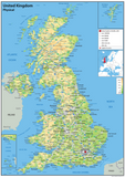
United Kingdom Physical Map
Tax included.
The United Kingdom of Great Britain and Northern Ireland (or simply the UK) in Western Europe is made up of four separate countries:
- England (capital: London)
- Wales (capital: Cardiff)
- Scotland (capital: Edinburgh)
- Northern Ireland (capital: Belfast)
This United Kingdom physical map shows height of terrain using colourful shading and also features motorways, major roads, cities and towns. It is a clear and colourful map to study from.
Laminated option: Paper finished with a durable gloss laminate.
Vinyl option: Heavy weight vinyl with metal eyelets.
Mounted Board - Printed on a rigid plastic board using stay-fast, waterproof inks. Includes holes and fixings. Please note - mounted maps require extra handling time (approx 14 days).


